Discover a world of alpine wonders with these ten remarkable hikes accessible by public transport from Zermatt. From the iconic Matterhorn views to the record-breaking Charles Kuonen Suspension Bridge, each trail offers a unique adventure in the heart of the Swiss Alps. Whether you're looking for a challenging trek along the Monte Rosa Tour or a family-friendly walk through larch forests, the Zermatt region has something for every hiker.
The hikes are sorted by travel time, making it easy to plan your mountain escape from Zermatt. Check out the map to explore thousands of destinations and activities, reachable from any starting point in Switzerland.
Much more on ovunta.com/en/map
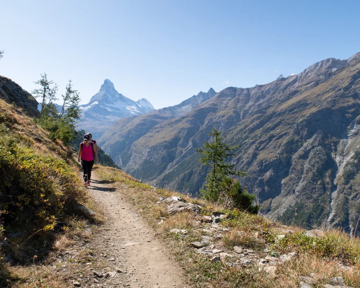
The edelweiss can be admired at a variety of habitats in the Zermatt mountains. It won’t grow on ground formed of crystalline rock, but it flourishes on calcareous sediments – despite the often harsh conditions. The fleecy hairs help protect the flowers from solar radiation, frost and aridity. The seeds require exposure to frost before they can germinate the following year.Hikers on this trail experience a magical moment on the climb up to Trift as the pinnacle of the Matterhorn emerges unexpectedly from behind a hilltop. Who’ll spot it first? The path then continues to one of Zermatt’s finest viewpoints, at Höhbalmen. The panorama is breathtaking: the north face of the Matterhorn with the Zmuttgrat ridge, the Breithorn, Liskamm and the Monte Rosa massif. Edelweiss: a protected plant Information panels about the plants along the way Between the Gasthaus Edelweiss and the Berggasthaus Trift hotels: edelweiss at eye level (right-hand side) Unusual view of the Monte Rosa massif Possible encounters with Valais Blacknose sheep and Valais Blackneck goats New route: Due to construction work on the Zermatt - Trift route, the Trifthütte is reached via Schweifinen. The hike is extended by around 1.5 hours. Alternatively, you can take the signpost to the left towards Höhbalmen at the start of the hike. Please note that neither the Edelweiss nor the Trift mountain hut will be reached.
 22.6 km
 1395 m
 1395 m
 8h 50m
Difficulty: Hard

Maximum elevation: 2745m

Minimum elevation: 1602m
Learn more on
valais.ch
Travel between rocky passes and intensely green valleys from Verbier to Zermatt, through larch forests and juniper bushes, across vast expanses and along icy blue glaciers. Be sure to observe the changes in landscape, language, cuisine and culture as you move through the valleys. This high altitude route for trail runners does not follow the most direct line from start to finish, but skirts the buttresses, choosing the most picturesque and practicable paths through the Valais in the heart of the Swiss Alps. Each leg finishes in a charming mountain village or in a hut if the route continues at high altitude.
308.24 km18498 m18537 m69h 15mDifficulty: Hard
Maximum elevation: 3346m
Minimum elevation: 688m
Learn more on
valais.ch
| Zermatt, Bahnhof (08:32) | |
| 571 (3m) | |
| Zermatt, Spiss (08:35) |
These breathtakingly stunning views of nature were used as orientation points by those responsible for mapping out the path in the villages of St. Niklaus, Grächen, Randa, Täsch and Zermatt to create the Europaweg in 1997. The first stage from Grächen was redesigned in 2021 and now leads on a varied and spectacular route to the Europa Hut above Randa. From here it goes over the suspension bridge – the longest pedestrian suspension bridge in the Alps which traverses the Grabengufer. The bridge is 494 m long and 85 m above the chasm below at its highest point. The path then continues in the direction of Täschalp and finally to Zermatt. Herbriggen: Intermediate stage with hotel accommodation Täschalp: cheese and Ziger soft cheese for sale Current information: Due to falling rocks, a diversion is currently in place at Täschgufer. From Bärgji in Randa, the route leads down into the valley to Täsch and then back up to Täschalp.
39.05 km2550 m1882 m13h 30mDifficulty: Hard
Maximum elevation: 2347m
Minimum elevation: 1310m
Learn more on
valais.ch
| Zermatt (08:35) | |
| R40 (13m) | |
| Täsch (08:48) |
The path begins at the Randa train station, where the "Europabrücke" signs point in the correct direction. Through larchwood forests and past the "Hohtschugga" viewing point, hikers reach the "Charles Kuonen Suspension Bridge". At 494 m, it is the longest pedestrian suspension bridge in the Alps. It takes almost 10 minutes to cross it and in the middle, swaying walkers are at the highest point: 85 m above the Grabengufer. After crossing, the path continues right back to Randa. As an option, one could make a detour to the Europa hut after the bridge. Suitable for the entire family One may not have a fear of heights The crossing of the bridge is free of charge Viewing point from "Hohtschugga" at 1,749 m The Europa hut (built 1998/1999) stands on stilts The Europa hut is on the Europa path, as the name suggests, and thus also on the Monte Rosa tour.
8.62 km988 m988 m4h 0mDifficulty: Medium
Maximum elevation: 2267m
Minimum elevation: 1409m
Learn more on
valais.ch
After the adventures of the day before, this eighth leg takes place over several kilometres of gently sloping single track. Start with a steep climb from Randa, then follow the path to the Europaweg and across the Charles Kuonen Bridge, which at 494 metres is the longest suspension bridge in the world. Continue on the Europaweg, which undulates along the Matter Valley and allows you to see more of the Matterhorn with every step. Make sure you stop at the Täsch mountain pasture for a snack before continuing on your way. A steeper slope leads you to Blauherd, with ski lifts providing access to numerous hikes and viewpoints. Head for the Mountain Lodge Ze Seewjinu via the Stellisee and the Grünsee, and enjoy a good shower and a hot meal.
26.61 km1890 m1000 m6h 5mDifficulty: Hard
Maximum elevation: 2593m
Minimum elevation: 1403m
Learn more on
valais.ch
Leg 7 is undoubtedly the most adventurous on the Via Valais. The Turtmann hut is the start of a long ascent to the Schöllijoch, a pass that opens onto the Matter valley (Mattertal). The alpine path leading to the pass is rocky and partially equipped with cables. Follow the Brunegg glacier and below the Barrhorn before reaching the Schöllijoch, which is the most difficult passage of the entire Via Valais in technical terms. Descend with cables and metal steps and head down to the glacier below to join a rocky path. This requires the utmost caution throughout the 2,000 m long descent. Before reaching Randa, the route skirts the hillside and offers a panoramic view of the Matter valley. Finally, below the Weisshorn, the trail ends with a very steep descent to Randa.
19.31 km1186 m2296 m4h 50mDifficulty: Hard
Maximum elevation: 3342m
Minimum elevation: 1403m
Learn more on
valais.ch
| Zermatt (08:37) | |
| R41 (19m) | |
| Randa (08:56) |
The path leads past the lakes of the Stellisee, Grindjisee, Grünsee, Moosjisee and Leisee. Each of these mountain lakes is very different in terms of shape, colour, character and size, and has its own special attraction. The Leisee is good for swimming: children love it. The Grünsee looks out over a rather more rugged landscape, where Swiss stone pines nevertheless manage to grow among the scree and sand. The shores of the Grindjisee are home to rare flowers. And so on – each one promises a unique experience. Appropriate for children from age 6 Reflection of Matterhorn in Stellisee, Grindjisee and Leisee lakes Findeln Glacier moraine Swimming in the Leisee and Grünsee lakes Children’s playground at Leisee, good picnic site
9.76 km165 m454 m2h 30mDifficulty: Medium
Maximum elevation: 2584m
Minimum elevation: 2130m
Learn more on
valais.ch
| Zermatt (Talstation Sunnegga) (08:40) | |
| 2290 (5m) | |
| Sunnegga (08:45) |

This route from Furi down to Zermatt village offers views of the region's stunning scenery, always accompanied by the impressive Matterhorn. The untouched landscape surrounded by a magnificent mountain world is a true feast for the eyes.
5 km20 m260 m1h 10m
Barrier free: Yes

Landscape: With panoramic views
Tour published by:
SwitzerlandMobility
Learn more on
schweizmobil.ch
| Zermatt GGB (08:48) | |
| 48 (6m) | |
| Findelbach (08:54) |
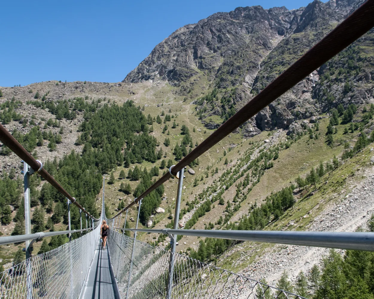
Are you prone to vertigo? Hopefully not. This loop tour takes you through larch forests and leads to an impressive record-breaking structure: the longest pedestrian suspension bridge in the Alps. It measures 494 metres, and at the highest point you find yourself 85 metres above the Grabengufer.
7 km680 m680 m3h 10mLandscape: Over a suspension bridge,With panoramic views
Tour published by:
SwitzerlandMobility
Learn more on
schweizmobil.ch

The 5-Lakes Trail is an extraordinary hiking path in the mountains of Zermatt. The Matterhorn is reflected in three of the mountain lakes and the view of the towering peaks is awe-inspiring. The trail connects the Stellisee, Grindjisee, Grünsee, Moosjisee and Leisee lakes.
11 km380 m660 m3h 15mLandscape: Along the water,With panoramic views
Tour published by:
SwitzerlandMobility
Learn more on
schweizmobil.ch


