
Discover a variety of hiking trails accessible from Riederalp by public transport. From alpine meadows to panoramic viewpoints, these routes offer diverse experiences in the heart of the Swiss Alps. Whether you're looking for a gentle stroll or a challenging trek, there's something for every hiker.
The following hikes and destinations are sorted by travel time from Riederalp, making it easy to plan your adventure. Check out the map to explore thousands of destinations and activities, reachable from any starting point in Switzerland.
Much more on ovunta.com/en/map
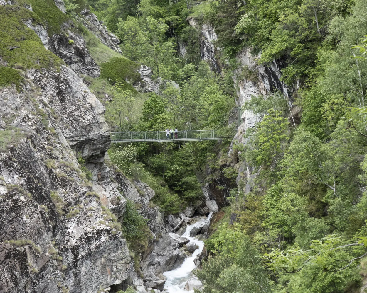
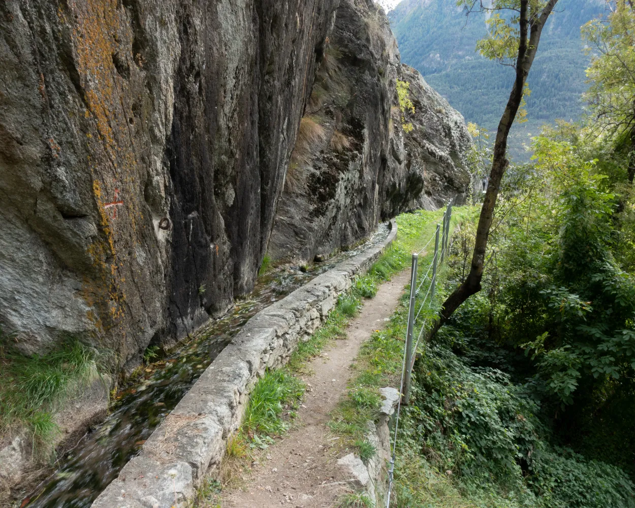
The dramatic Massa gorge is a gift of the Aletsch Glacier. Ice carved the canyon long ago; later, meltwater polished its rocks. Today, the glacier is invisible from inside the gorge – yet the river of ice remains the mightiest in the Alps. 23 km long and containing 27 billion tons of ice, the glacier forms the heart of the UNESCO World Heritage Site of “Swiss Alps Jungfrau-Aletsch”, just to the north. The vertiginous gorge is the highlight of this thrilling hike, which follows the route of a former irrigation channel, the Riederi. First mentioned in historical documents in 1385, it was built to carry glacial meltwater to the fields around Ried-Mörel. The Riederi is no longer in use, but the trail that follows its course – recently blasted out of the rock of the canyon – makes for a spectacular hike. You’ll need a good head for heights! The hike begins at Blatten, with a climb through forest to reach the Gibidum bridge. Once across the Massa river, the trail turns sharply southwards: first following the course of the gorge downstream, then turning north-west up the valley of the Rhône. Here, the path traverses woodland and pastures to reach the village of Ried-Mörel. The latter stage of the walk reveals sweeping views up and down the Rhône valley. The route along the former irrigation channel is now a theme trail devoted to water. The ancient methods used to carry water across the landscapes of Valais are similar to those still used in Nepal. Info panels (in French and German) reveal the similarities between the two traditions, show the extraordinary efforts made to create and maintain the networks – and explore the customs and myths linked to them. Highlights Varied hike through forest, along a spectacular gorge and then across open meadows, with magnificent views throughout Short climb at start, then very gently sloping path – but a good head for heights required! Water-themed trail exploring the shared heritage of Valais and Nepal
 7.99 km
 101 m
101 m 263 m
263 m 3h 0m
3h 0m| Riederalp West (09:03) | |
| A1-2 (5m) | |
| Ried-Mörel (09:08) |
An ancient trade route connected the upper Rhône valley with Lombardy via the village of Grengiols, the Binntal valley and the Albrun Pass. Today, the lower section of the “Römerweg” (“Roman Path”) offers walkers a delightful experience of the pristine scenery of the Binntal Landscape Park, picturesque hamlets and charming Grengiols. This historical village has remained virtually unchanged since 1861, when the new Furka Pass road diverted traffic to the northern side of the Rhône valley. The trail begins at a remote bus stop on the road into the Binntal valley, just before the main tunnel, and finishes at Betten railway station, on the floor of the Rhône valley. Along the way, it leads through fragrant pine forest and across flower-filled meadows, with glorious views of the dramatic Binntal gorges and the sweeping Rhône valley. From Steinmatten bus stop, the trail drops down to the Römerbrücke (“Roman bridge”) across the Binn river before climbing through peaceful forest to a pair of sleepy hamlets – Blatt and Hockmatta – each with an ancient chapel. Further on, Grengiols is known as the home of a wild variety of tulip, unique worldwide. The protected plants are known in local dialect as “Roman tulips”; about 3,000 blossom each spring, usually in the second half of May, in the village’s old rye fields. An attractive theme trail leading to the “tulip hill” and other natural sites opened in 2009, with the addition of a brand-new path across open meadows and through forest in 2014. Our hike follows first the new extension and then part of the original trail before reaching the village heart. With its narrow, steep main alley and picturesque village square, Grengiols is a historical site of national importance. Highlights: Ancient trail through forest, meadows and sleepy hamlets, with gorgeous views Theme trail devoted to the Grengiols tulip, unique worldwide
12.97 km86 m656 m3h 45m| Riederalp Mitte (08:39) | |
| A3 (12m) | |
| Mörel (Riederalpbahn) (08:51) |
| Mörel (08:57) | |
| R42 (6m) | |
| Bettmeralp Talstation (09:03) |
When the pioneering Lötschberg tunnel and railway line opened in 1913, the new route provided the first year-round link between Valais and the Swiss capital. Together with the Simplon tunnel, it offered a fast and comfortable way of travelling across and under the Alps. The stretch of line south of the tunnel is the setting for one of the region’s best-loved hikes: the Lötschberger-Südrampe («Lötschberg south ramp»). To celebrate the line’s centenary, the trail was extended from Lalden station all the way to the historical town of Brig. Our hike begins at Eggerberg, just west of Lalden, about 200 vertical metres above the valley floor. From here it traverses the sunny, south-facing slopes until dropping down to the Rhône by Brig. The railway is quieter following the opening of another pioneering line in 2007: the Lötschberg base tunnel, 400 vertical metres lower, which can accommodate trains travelling at up to 250 km/h. The first stretch of the hike leads fairly close to the railway line until it passes the Brigerbad thermal pool complex down on the valley floor. With its 12 indoor and outdoor pools, its water slides and spa, this is one of the country’s largest thermal spa facilities. The trail now traces a route some way above the railway line: first below the saffron-growing village of Mund, then along a «Suone» irrigation channel, the Driestneri, created to provide water for the line’s fire prevention installations. Just before reaching Naters, the trail passes over a former top-secret underground fortress. Today this hosts two museums: one devoted to the site’s military history, and another to the Swiss Guard in the Vatican, for which Naters has supplied more soldiers than any other Swiss municipality. The south ramp is mostly walked in the direction of Brig, but it is also very attractive in the opposite direction. Highlights: Theme trail with info panels exploring more than a century of pioneering rail history Sunny position, open views across Rhône valley Two fascinating museums plus Brig: historical charm and Mediterranean atmosphere
10.38 km184 m377 m3h 30m| Riederalp Mitte (08:39) | |
| A3 (12m) | |
| Mörel (Riederalpbahn) (08:51) |
| Mörel (08:57) | |
| R42 (9m) | |
| Brig Bahnhofplatz (09:06) |
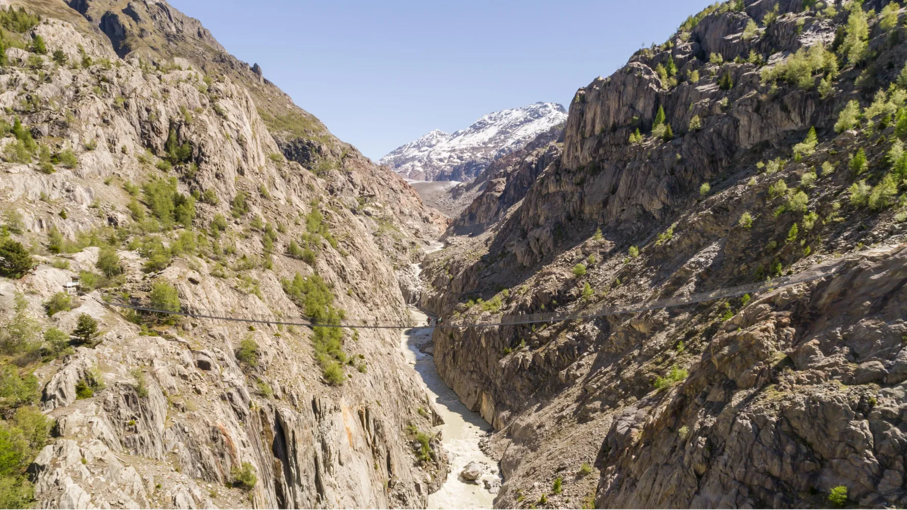
Part of the route between Fiesch and Lax is inaccessible following a landslide this spring near the Altbach stream. Following the success of the Stoneman Glaciara for mountain bikers, here is the Stoneman Glaciara Hike, an exclusive adventure for hikers and trail runners. Experience these magical routes on paths deep within mystical forests leading up to incredible views of a sea of mountain peaks of over 4,000 m high. On the program: a breathtaking 3,150 metre difference in height, two suspension bridges spanning the valley, a spectacular ridge walk and the billions of tons of ice of Central Europe’s mightiest glacier – that’s the Stoneman Glaciara Hike. It is entirely up to you whether you wish to trail run or hike, and experience the Stoneman Glaciara Hike in one, two or three daily stages. Get the official starter pack and follow the perfectly signposted route for a stunning adventure.
63.37 km3341 m3341 m22h 35m
Difficulty: Hard

Maximum elevation: 2839m

Minimum elevation: 1005m
Learn more on
valais.ch
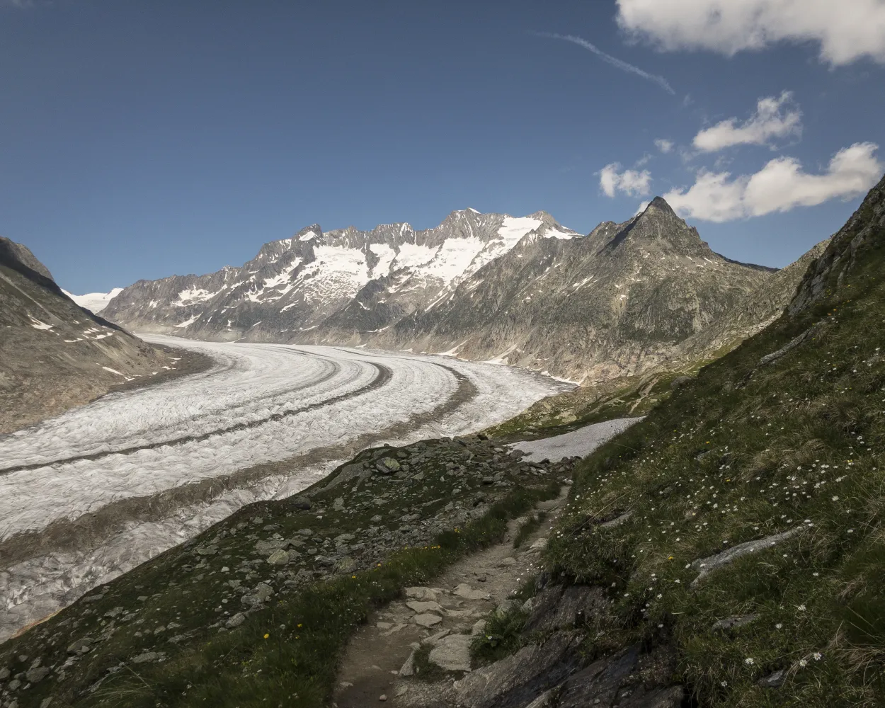
This loop hike passes through the spectacular scenery of the Aletsch region and offers constant views of the Aletsch glacier, the largest glacier in the Alps. The hike begins at the Moosfluh mountain station, one of the four viewpoints of the Aletsch Arena. Follow the panoramic path towards the Bettmerhorn, with a continuous view of the glacier. After a short descent, you will approach the glacier (Chazulecher), before returning through the Aletsch forest. The climb is demanding but well worth it, with impressive views. From Alte Stafel, perhaps the most beautiful viewpoint, the path leads back to Moosfluh. The descent to Riederalp can be made on foot or comfortably by train.
6.84 km399 m399 m2h 50mDifficulty: Medium
Maximum elevation: 2333m
Minimum elevation: 1950m
Learn more on
valais.ch
The Jungfrau-Aletsch Protected Area has been a UNESCO World Heritage Site since 2001. Situated in the heart of this region, the Aletsch Glacier - 20km long and up to 1,000m thick - is the largest in the Alps. The trail runs along this giant piece of ice on a gently sloping path while offering a spectacular view of the surrounding peaks including the Aletschhorn, Matterhorn, Weisshorn, Dom, and other incredible 4,000-meter peaks. The Gletscherstube Märjelen hut offers a rest stop approximately mid-way. From here, the trail bends around the Tälligrat and returns to to Bettmeralp along a wilder, less frequented, but no less stunning route. The loop passes through Unners Tälli, and below Fiescheralp, before finishing on a soft forest trail leading back to town.
26.99 km878 m878 m4h 45mDifficulty: Medium
Maximum elevation: 2392m
Minimum elevation: 1931m
Learn more on
valais.ch
| Riederalp (Moosfluh) (08:40) | |
| E (10m) | |
| Moosfluh (08:50) |
Scenic high-level trail with panoramic views of the Valais Alps and views down into the Rhone Valley. Variety of attractions along the route: thermal spa in Leukerbad, viaducts on the Lötschberg-Südrampe, splashing water channels and the Museum of the Swiss Guard at Naters.
76 km3300 m4100 m
Landscape: With panoramic views
Tour published by:
SwitzerlandMobility
Learn more on
schweizmobil.ch
Suonen (irrigation channels) and the BLS railway line accompany this stage. Impressive view of the Baltschieder viaduct. Pipes for irrigating the dry south-facing slopes line the route. Information columns on the BLS Südrampe section and Swiss Guards Museum provide fascinating information.
17 km540 m900 m5h 0mTour published by:
SwitzerlandMobility
Learn more on
schweizmobil.ch
Three days under the spell of the Valais glacier landscape. Sensational scenic tour with many vantage points onto the two longest glaciers in the Alps. The grey-white of ice and rock contrasting with shades of green in the Aletschwald (forest) provides stunning scenic beauty.
30 km1850 m2400 m9h 0mLandscape: Over a suspension bridge,With panoramic views,Along a glacier
Tour published by:
SwitzerlandMobility
Learn more on
schweizmobil.ch
A string of vantage points provides a natural spectacle: to the north, the view of the Aletsch Glacier in the heart of the UNESCO World Heritage Site. To the south the 4000-metre peaks of Valais. On the gentle descent to the Märjelensee lake, cotton grasses and small tarns contrast with the rock and ice.
12 km820 m520 m4h 0mLandscape: With panoramic views,Along a glacier
Tour published by:
SwitzerlandMobility
Learn more on
schweizmobil.ch
Difficulty: Medium
Maximum elevation: 1453m
Minimum elevation: 1190m
Difficulty:
Maximum elevation: 1405m
Minimum elevation: 830m
Difficulty:
Maximum elevation: 900m
Minimum elevation: 672m
Learn more on
valais.ch
Learn more on
valais.ch
Learn more on
valais.ch


