Scopri una varietà di sentieri escursionistici accessibili da Riederalp con i mezzi pubblici. Dai prati alpini ai punti panoramici, questi percorsi offrono esperienze diverse nel cuore delle Alpi svizzere. Che tu sia alla ricerca di una passeggiata tranquilla o di un'escursione impegnativa, c'è qualcosa per ogni escursionista.
Le seguenti escursioni e destinazioni sono ordinate in base al tempo di viaggio da Riederalp, rendendo facile pianificare la tua avventura. Esplora la mappa per scoprire migliaia di destinazioni e attività, raggiungibili da qualsiasi punto di partenza in Svizzera.
Molto di più su ovunta.com/it/map
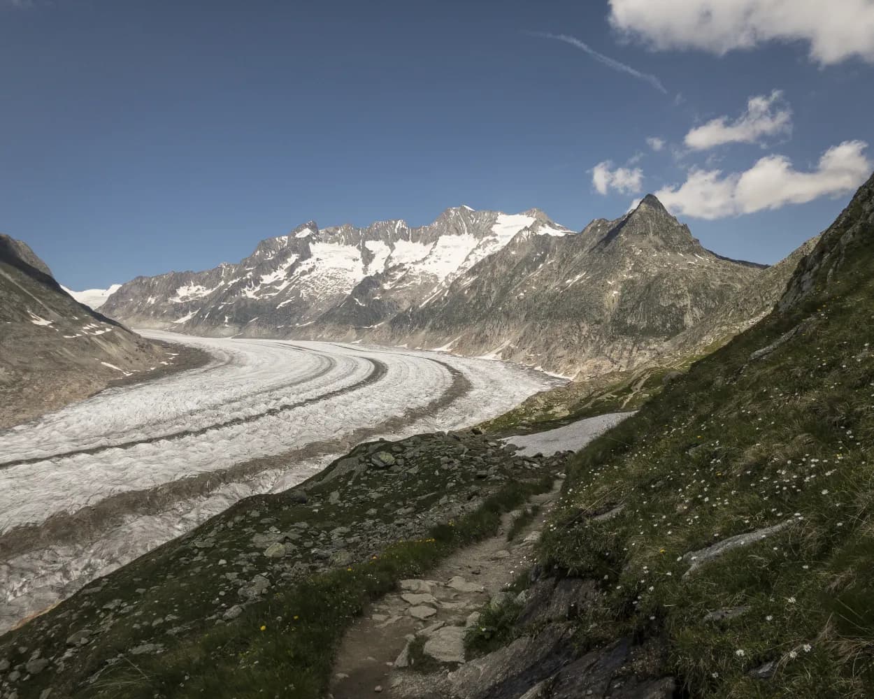
The dramatic Massa gorge is a gift of the Aletsch Glacier. Ice carved the canyon long ago; later, meltwater polished its rocks. Today, the glacier is invisible from inside the gorge – yet the river of ice remains the mightiest in the Alps. 23 km long and containing 27 billion tons of ice, the glacier forms the heart of the UNESCO World Heritage Site of “Swiss Alps Jungfrau-Aletsch”, just to the north. The vertiginous gorge is the highlight of this thrilling hike, which follows the route of a former irrigation channel, the Riederi. First mentioned in historical documents in 1385, it was built to carry glacial meltwater to the fields around Ried-Mörel. The Riederi is no longer in use, but the trail that follows its course – recently blasted out of the rock of the canyon – makes for a spectacular hike. You’ll need a good head for heights! The hike begins at Blatten, with a climb through forest to reach the Gibidum bridge. Once across the Massa river, the trail turns sharply southwards: first following the course of the gorge downstream, then turning north-west up the valley of the Rhône. Here, the path traverses woodland and pastures to reach the village of Ried-Mörel. The latter stage of the walk reveals sweeping views up and down the Rhône valley. The route along the former irrigation channel is now a theme trail devoted to water. The ancient methods used to carry water across the landscapes of Valais are similar to those still used in Nepal. Info panels (in French and German) reveal the similarities between the two traditions, show the extraordinary efforts made to create and maintain the networks – and explore the customs and myths linked to them. Highlights Varied hike through forest, along a spectacular gorge and then across open meadows, with magnificent views throughout Short climb at start, then very gently sloping path – but a good head for heights required! Water-themed trail exploring the shared heritage of Valais and Nepal
 7.99km
 101m
101m 263m
263m 3h 0m
3h 0m
Altitudine minima: 1190m

Difficoltá: Media

Altitudine massima: 1453m
| Riederalp West (09:03) | |
| A1-2 (5m) | |
| Ried-Mörel (09:08) |
An ancient trade route connected the upper Rhône valley with Lombardy via the village of Grengiols, the Binntal valley and the Albrun Pass. Today, the lower section of the “Römerweg” (“Roman Path”) offers walkers a delightful experience of the pristine scenery of the Binntal Landscape Park, picturesque hamlets and charming Grengiols. This historical village has remained virtually unchanged since 1861, when the new Furka Pass road diverted traffic to the northern side of the Rhône valley. The trail begins at a remote bus stop on the road into the Binntal valley, just before the main tunnel, and finishes at Betten railway station, on the floor of the Rhône valley. Along the way, it leads through fragrant pine forest and across flower-filled meadows, with glorious views of the dramatic Binntal gorges and the sweeping Rhône valley. From Steinmatten bus stop, the trail drops down to the Römerbrücke (“Roman bridge”) across the Binn river before climbing through peaceful forest to a pair of sleepy hamlets – Blatt and Hockmatta – each with an ancient chapel. Further on, Grengiols is known as the home of a wild variety of tulip, unique worldwide. The protected plants are known in local dialect as “Roman tulips”; about 3,000 blossom each spring, usually in the second half of May, in the village’s old rye fields. An attractive theme trail leading to the “tulip hill” and other natural sites opened in 2009, with the addition of a brand-new path across open meadows and through forest in 2014. Our hike follows first the new extension and then part of the original trail before reaching the village heart. With its narrow, steep main alley and picturesque village square, Grengiols is a historical site of national importance. Highlights: Ancient trail through forest, meadows and sleepy hamlets, with gorgeous views Theme trail devoted to the Grengiols tulip, unique worldwide
12.97km86m656m3h 45mAltitudine minima: 830m
Altitudine massima: 1405m
Difficoltá:
Learn more on
valais.ch
| Riederalp Mitte (08:39) | |
| A3 (12m) | |
| Mörel (Riederalpbahn) (08:51) |
| Mörel (08:57) | |
| R42 (6m) | |
| Bettmeralp Talstation (09:03) |
When the pioneering Lötschberg tunnel and railway line opened in 1913, the new route provided the first year-round link between Valais and the Swiss capital. Together with the Simplon tunnel, it offered a fast and comfortable way of travelling across and under the Alps. The stretch of line south of the tunnel is the setting for one of the region’s best-loved hikes: the Lötschberger-Südrampe («Lötschberg south ramp»). To celebrate the line’s centenary, the trail was extended from Lalden station all the way to the historical town of Brig. Our hike begins at Eggerberg, just west of Lalden, about 200 vertical metres above the valley floor. From here it traverses the sunny, south-facing slopes until dropping down to the Rhône by Brig. The railway is quieter following the opening of another pioneering line in 2007: the Lötschberg base tunnel, 400 vertical metres lower, which can accommodate trains travelling at up to 250 km/h. The first stretch of the hike leads fairly close to the railway line until it passes the Brigerbad thermal pool complex down on the valley floor. With its 12 indoor and outdoor pools, its water slides and spa, this is one of the country’s largest thermal spa facilities. The trail now traces a route some way above the railway line: first below the saffron-growing village of Mund, then along a «Suone» irrigation channel, the Driestneri, created to provide water for the line’s fire prevention installations. Just before reaching Naters, the trail passes over a former top-secret underground fortress. Today this hosts two museums: one devoted to the site’s military history, and another to the Swiss Guard in the Vatican, for which Naters has supplied more soldiers than any other Swiss municipality. The south ramp is mostly walked in the direction of Brig, but it is also very attractive in the opposite direction. Highlights: Theme trail with info panels exploring more than a century of pioneering rail history Sunny position, open views across Rhône valley Two fascinating museums plus Brig: historical charm and Mediterranean atmosphere
10.38km184m377m3h 30m| Riederalp Mitte (08:39) | |
| A3 (12m) | |
| Mörel (Riederalpbahn) (08:51) |
| Mörel (08:57) | |
| R42 (9m) | |
| Brig Bahnhofplatz (09:06) |
The Trusera is the most easterly Suone – or irrigation channel – of any significance in the Valais. First mentioned in a purchase document dating from 1499, it draws its water from the Milibach stream in the Rappental valley. The irrigation channel was out of use between 1994 and 2006, but was later restored by numerous helpers at great financial expense. For the most part, it runs through shady forests, serving to irrigate herb gar- dens in the Binnackern area. During the blooming period, various types of native orchid, including the red hellborine, adorn the footpath.
8.2km395m3h 0mDifficoltá:

Paesaggio: Lungo l'acqua,Lungo un canale d'irrigazione
Learn more on
valais.ch
and on
valrando.ch
| Riederalp Mitte (08:39) | |
| A3 (12m) | |
| Mörel (Riederalpbahn) (08:51) |
| Mörel (08:57) | |
| R42 (20m) | |
| Lax (09:17) |
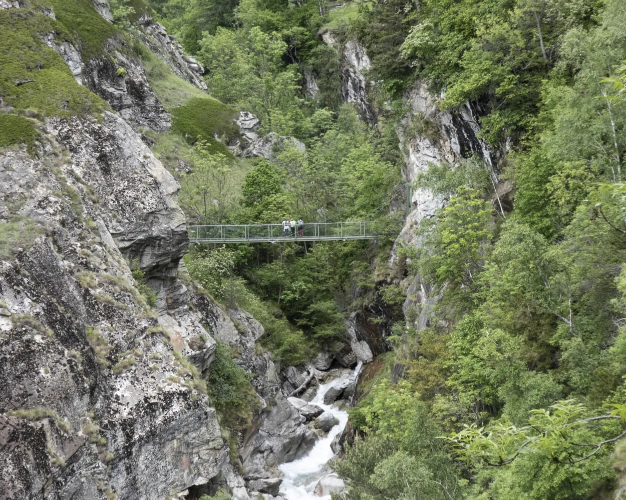
Part of the route between Fiesch and Lax is inaccessible following a landslide this spring near the Altbach stream. Following the success of the Stoneman Glaciara for mountain bikers, here is the Stoneman Glaciara Hike, an exclusive adventure for hikers and trail runners. Experience these magical routes on paths deep within mystical forests leading up to incredible views of a sea of mountain peaks of over 4,000 m high. On the program: a breathtaking 3,150 metre difference in height, two suspension bridges spanning the valley, a spectacular ridge walk and the billions of tons of ice of Central Europe’s mightiest glacier – that’s the Stoneman Glaciara Hike. It is entirely up to you whether you wish to trail run or hike, and experience the Stoneman Glaciara Hike in one, two or three daily stages. Get the official starter pack and follow the perfectly signposted route for a stunning adventure.
63.37km3341m3341m22h 35mAltitudine massima: 2839m
Difficoltá: Difficile
Altitudine minima: 1005m
Learn more on
valais.ch
| Riederalp Mitte (08:39) | |
| A3 (12m) | |
| Mörel (Riederalpbahn) (08:51) |
| Mörel (08:57) | |
| R42 (23m) | |
| Fiesch Feriendorf (09:20) |
In tre tappe da un giorno, la Via Stockalper conduce attraverso valli soleggiate, boschi meravigliosi e gole rocciose nell’Alto Vallese. Mentre la prima tappa sale ripida da Briga al Passo del Sempione, le due tappe successive portano costantemente verso vale, prima a Simplon Dorf e poi a Gondo.
30km1800m1600m10h 0mPaesaggio: Lungo l'acqua,Attraverso un passo,Accanto a castelli,Attraverso una gola
Tour pubblicato da:
SvizzeraMobile
Learn more on
schweizmobil.ch
Panoramico sentiero in cresta con vista sulle Alpi vallesane e sulla valle del Rodano. Tracciato molto variegato: piscine termali a Leukerbad, viadotti sulla rampa sud del Lötschberg, bisses gorgoglianti e, a Naters il Museo della Guardia Svizzera.
76km3300m4100mPaesaggio: Con vista panoramica
Tour pubblicato da:
SvizzeraMobile
Learn more on
schweizmobil.ch

Les antiche «bisses» e la linea delle BLS accompagnano questa tappa. Vista sul viadotto di Baltschieder. I tubi per l'irrigazione del versante sud fiancheggiano il percorso. Colonne informative sulla «rampa sud» delle Ferrovie BLS e il Museo della Guardia Svizzera danno interessanti informazioni.
17km540m900m5h 0mTour pubblicato da:
SvizzeraMobile
Learn more on
schweizmobil.ch
Seguendo le strette e profonde gole a sud di Briga, questo percorso conduce attraverso meravigliosi boschi di pini e zone golenali protette. Sentieri di montagna scavati nella roccia si snodano lungo il pendio dall’alto della gola della Saltina. Il percorso costeggia quindi l’argine del Taferna che si fa strada tra massi enormi.
12km1600m260m5h 20mPaesaggio: Attraverso un passo,Con vista panoramica
Tour pubblicato da:
SvizzeraMobile
Learn more on
schweizmobil.ch
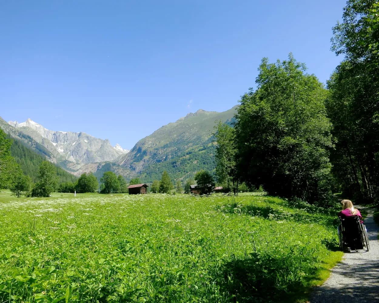
Un'escursione da Fiesch a Fieschertal, sempre seguendo il vivace torrente Wysswasser, è una vera esperienza naturale. Qui si ammira il meglio delle montagne vallesane. Non resta nient'altro da fare che rilassarsi e divertirsi.
3km70m20m40mPaesaggio: Lungo l'acqua

Accessibile: Si
Tour pubblicato da:
SvizzeraMobile
Learn more on
schweizmobil.ch
| Riederalp Mitte (08:39) | |
| A3 (12m) | |
| Mörel (Riederalpbahn) (08:51) |
| Mörel (08:57) | |
| R42 (25m) | |
| Fiesch (09:22) |
Altitudine minima: 672m
Altitudine massima: 900m
Difficoltá:
Learn more on
valais.ch
Learn more on
valais.ch