These ten hiking destinations are easily accessible from Leukerbad by public transport, offering a mix of thermal springs, alpine meadows, and stunning mountain vistas. From the Loop to Flüealp alpine pasture to the challenging Ascent of the Torrenthorn, each trail showcases the natural beauty of the region. Whether you're looking for a relaxing walk or a more strenuous hike, there's something for everyone in the area surrounding this famous spa town.
The hikes are listed in order of travel time from Leukerbad, making it easy to plan your adventure based on your schedule and preferences. Check out the map to explore thousands of destinations and activities, reachable from any starting point in Switzerland.
Much more on ovunta.com/en/map
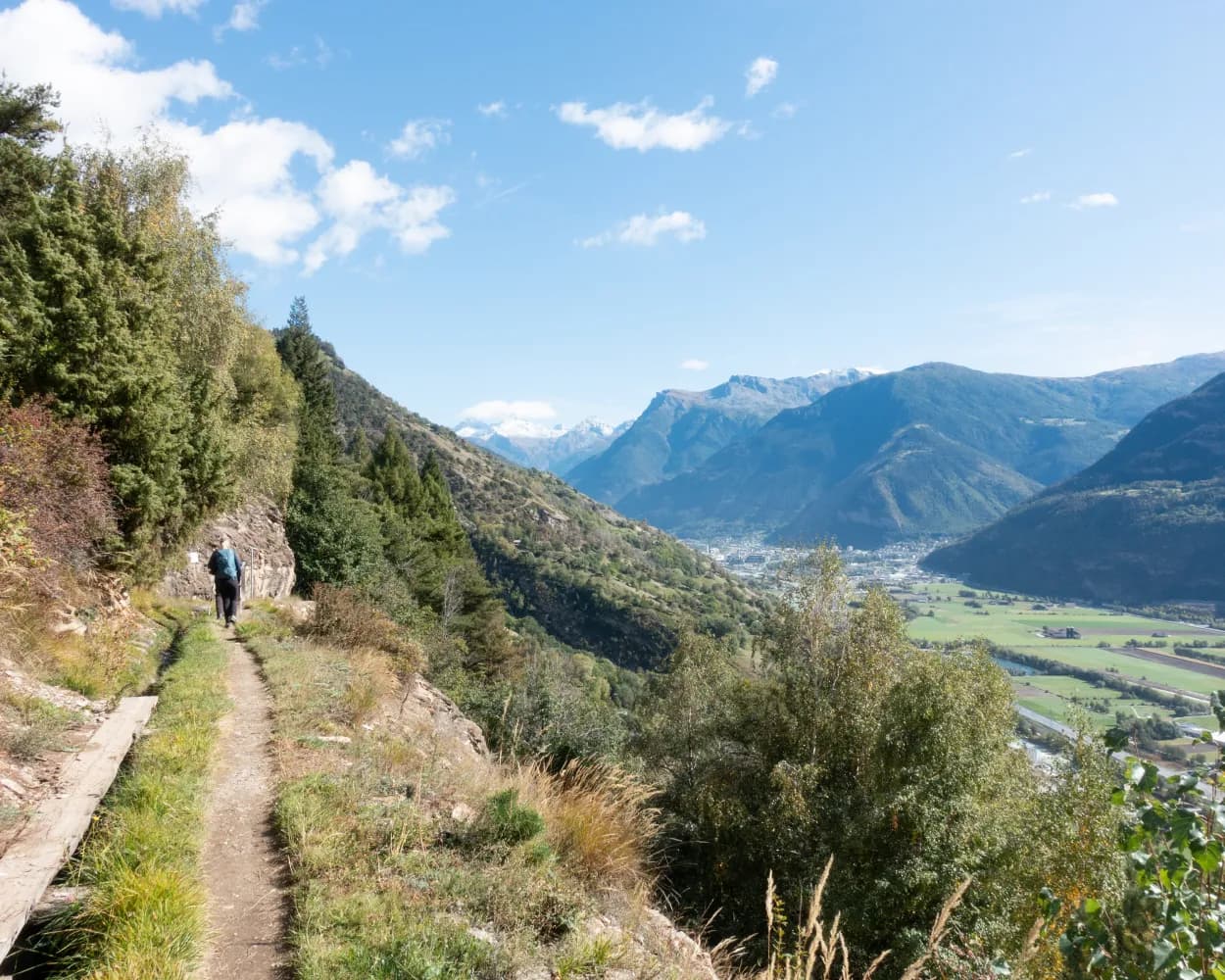
This dramatic walk packs in tremendous variety, even for Valais: culture and history, spectacular mountain scenery, dramatic gorges, winemaking villages and glorious views of the wildest stretch of the Rhône valley. The hike falls into two halves. It begins at the spa resort of Leukerbad with a descent of the wild Dala valley. Lower down, the trail diverts through the vineyards of two of Valais’ most charming winemaking villages. The route finishes just short of the river Raspille, which marks the border between German- and French-speaking Valais. The trail is marked as a Kulturweg – «Cultural Pathway» – for good reason. The ancient Romans came this way to frequent Leukerbad’s hot mineral springs, the most abundant in the Alps. For centuries, the Dala valley was an important trade route into Valais – from the Bernese Oberland via the Gemmi Pass. The very first group package tour to Switzerland, organised by Thomas Cook, travelled up the Dala valley in 1863, and the route is now commemorated as the ViaCook. Part of our trail follows the route of a disused railway line, which ran between Leuk and Leukerbad from 1915 to 1967. But it was another railway line that definitively diverted traffic away from the valley: the Lötschberg, which opened in 1913. In 2007, the pioneering new Lötschberg tunnel opened: 400 metres lower, it can accommodate trains travelling up to 250 km/h. The first half of the trail follows a scenic route through the Dala valley, incorporating sections of the old Roman path and former railway line. The second stretch leads through the vineyards of Varen (known for its Pinot Noir wines made with grapes grown by natural methods) and Salgesch (home to one of the two sites of the Wine Museum of Valais). Highlights: Leukerbad spa resort – the most abundant hot springs in the Alps Wild Dala valley: Roman path, historical villages, picturesque chapels Winegrowing villages of Varen and Salgesch, superb views over untamed Rhône
 16.23 km
 230 m
230 m 850 m
850 m 3h 0m
3h 0m| Leukerbad, City (09:21) | |
| 481 (1m) | |
| Leukerbad, Schulen (09:22) |
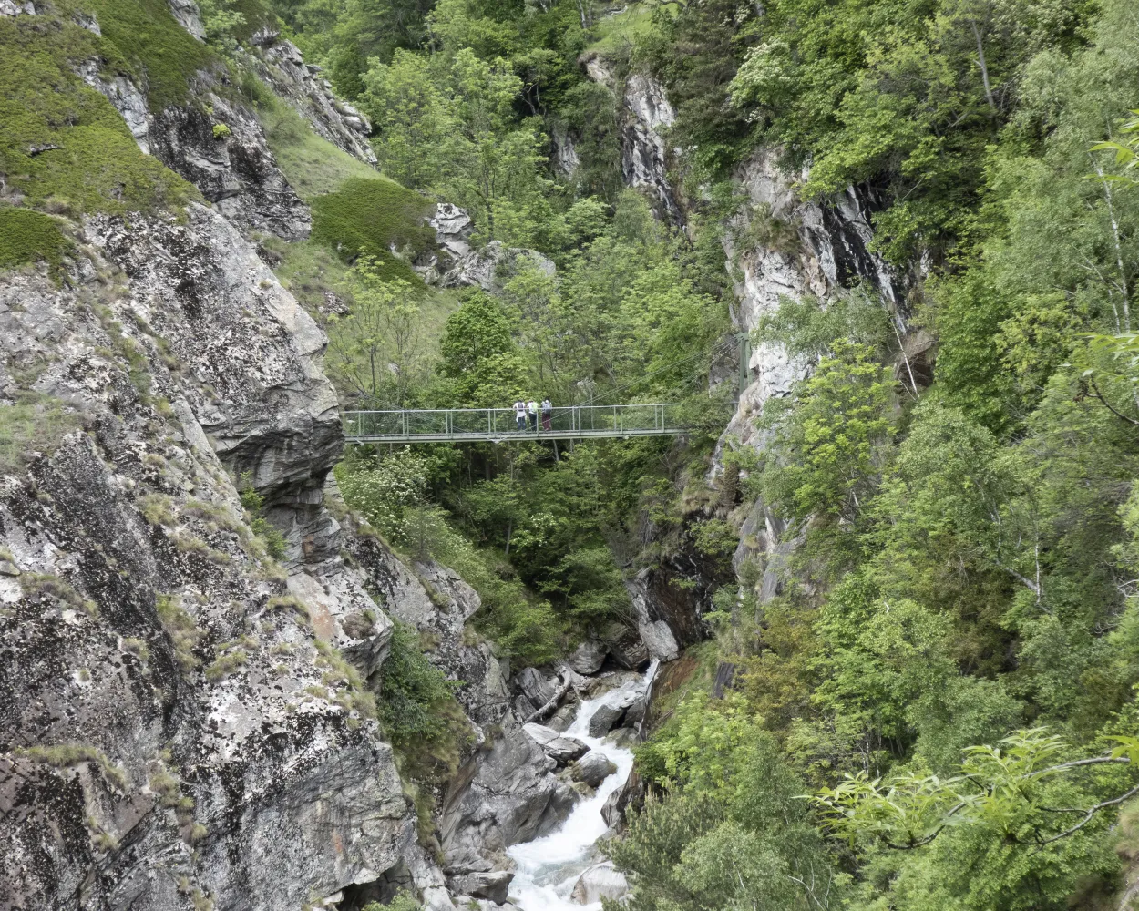
Discover the dramatic rocky Alpine terrain around the Wildstrubel massif on this hike to the Lämmeren mountain refuge and back. The route crosses the Lämmerenboden plateau, with its fissured calcareous rock and mounds of schist. The warden of the Lämmeren hut has created a glacier trail here in collaboration with the University of Bern. Along the trail, information stations provide fascinating information on the geology, landscape features and biology of this unique environment. A brochure on the theme trail is available. At the far end of Lämmerenboden, a climb of about 200 vertical metres leads to the Lämmeren refuge. Difficult passages are secured with chains. With a little luck, you may spot some of the ibex that regularly gather in the vicinity of the hut. Assorted trails offer the chance to explore the surrounding landscapes; climbing enthusiasts can choose from a number of routes of varying difficulty. For the return leg of the hike, follow the same route back as far as Lämmerenboden, and then walk eastwards to the Lämmerensee lake. When you reach the left bank of the Lämmerendalu river, you rejoin the glacier trail. A little before the Daubensee lake, the trail branches to the right to return to the Gemmi Pass.
9.34 km321 m321 m3h 15m
Difficulty: Medium

Maximum elevation: 2502m

Minimum elevation: 2256m
Learn more on
valais.ch
| Leukerbad, City (09:21) | |
| 481 (2m) | |
| Leukerbad, Gemmi-Bahnen (09:23) |
| Leukerbad (Talstation Gemmi) (09:30) | |
| PB (6m) | |
| Gemmipass (09:36) |
Highlight of this walk is the ascent of a sequence of eight wooden ladders, which once provided the only link between Leukerbad and Albinen. The latter is a traditional Valais village of ancient wooden chalets blackened by sunshine. The two-hour hike from Leukerbad to Albinen is only for those with a good head for heights. Starting in the village of Leukerbad, the trail leads southwards and through the Lochwald forest to reach the beginning of the thrilling ascent of the Albinen ladders. These once provided the only link between Leukerbad and Albinen, and were primarily used for the transport of agricultural goods. It is also likely – although unproven – that the ladders formed an extension of the Gemmi Pass route linking the Kander valley with the Rhône valley. The sequence of ladders represents a climb of about 100 vertical metres and ends by the base station of the Flaschen–Torrentalp gondola. Here, the Restaurant Flaschen offers a welcome break for refreshments. The trail continues, partly through forest, partly through fields and meadows, passing above the hamlet of Dorben before reaching Albinen. This is a typical Valais mountain village with many well-preserved houses and barns. Only the village church is built in modern style, as its predecessor was destroyed in an earthquake. The population was largely self-sufficient until the mid-20th century; the access road was built only in the 1960s. To make the most efficient use of the land available, locals built their houses very close together. As all the gables of the houses face the same way, across the valley, the village has a remarkably uniform appearance, and is today a heritage site of national importance. From Albinen, hikers can either continue in the direction of the mountain villages of Guttet-Feschel and Erschmatt or return to Leukerbad. In order to follow a different route back, walkers can return to Leukerbad via Torrentalp and another dramatic passage, the Wolfstritt. Highlights: The dramatic Albinen ladders, which once provided the only link between Leukerbad and Albinen. The unspoilt mountain village of Albinen with its well-preserved wooden houses dating from the 17th and 18th
6.26 km185 m317 m2h 0m| Leukerbad, City (09:21) | |
| 481 (5m) | |
| Leukerbad, Obere Maressen (09:26) |
| Leukerbad, Obere Maressen (09:56) | |
| 481 (3m) | |
| Leukerbad, Torrent-Bahnen (09:59) |
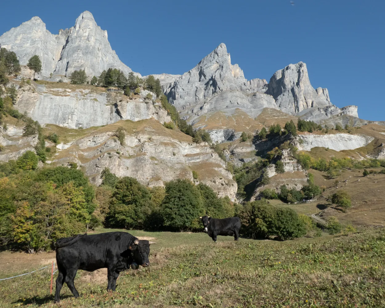
Starting point for the hike is Rinderhütte, the summit station of the cable car from Leukerbad. The climb leads across the alpine pastures of Torrent, where many cows, sheep and goats spend the summer. The path leads steadily towards the western ridge of the Torrenthorn via the Rinderhalte pastures, where hikers will frequently hear the whistling of marmots. At an altitude of around 2,700 m, the grassy alpine meadows give way to rocky terrain. Up on the ridge you enjoy a magnificent view of the Majingalp pastures and the dramatic Montanji cliffs: best known for the precipitous Gemmiwand rock face above Leukerbad, they extend eastwards all the way to the summit of the Balmhorn on the border between Valais and the Bernese Oberland. After about another kilometre you reach the summit of the Torrenthorn, also known as the “Rigi of Valais”. From the summit you have a complete 360° panoramic view, and on a clear day you can see peaks including the Jungfrau, Bietschhorn, Monte Leone, Weissmies, the Mischabel massif, Monte Rosa, Matterhorn, Grand Combin and even Mont Blanc. For the return leg, the most direct route is along the ridge and via the historical Hotel Torrenthorn back to Rinderhütte. However, it is also possible to extend the hike via alternative descents. For example, you can follow the ridge south towards the Schafberg and climb another peak before following the alpine route (marked white-blue-white) down to Rinderhütte. Another alternative is to turn north at Rinderhalte to descend to the Majingalp pastures, and then walk along the Dala river back down to Leukerbad. Highlights: Summit of the Torrenthorn, with superb panoramic views of the Valais and Bernese Alps – and on a clear day, the French Alps. Many options for extending the hike via a variety of alternative descent routes.
6.84 km690 m690 m3h 0mThis great mountain hike leads from Lauchernalp first on the Lötschentaler Höhenweg via Hockenalp and Kummenalp to Restialp. From here, the mountain trail climbs steadily to the Restipass at 2,626 m.a.s.l. From the top of the pass, the trail leads through a beautiful mountain landscape, gently descending past small lakes to the Rinderhütte station, from where the cable car takes you to Leukerbad.
14.84 km896 m530 m5h 30mDifficulty: Medium
Maximum elevation: 2633m
Minimum elevation: 1969m
Learn more on
valais.ch
| Leukerbad, City (09:21) | |
| 481 (5m) | |
| Leukerbad, Obere Maressen (09:26) |
| Leukerbad, Obere Maressen (09:56) | |
| 481 (3m) | |
| Leukerbad, Torrent-Bahnen (09:59) |
| Leukerbad (Torrentbahn) (10:10) | |
| 2242 (5m) | |
| Rinderhütte (10:15) |
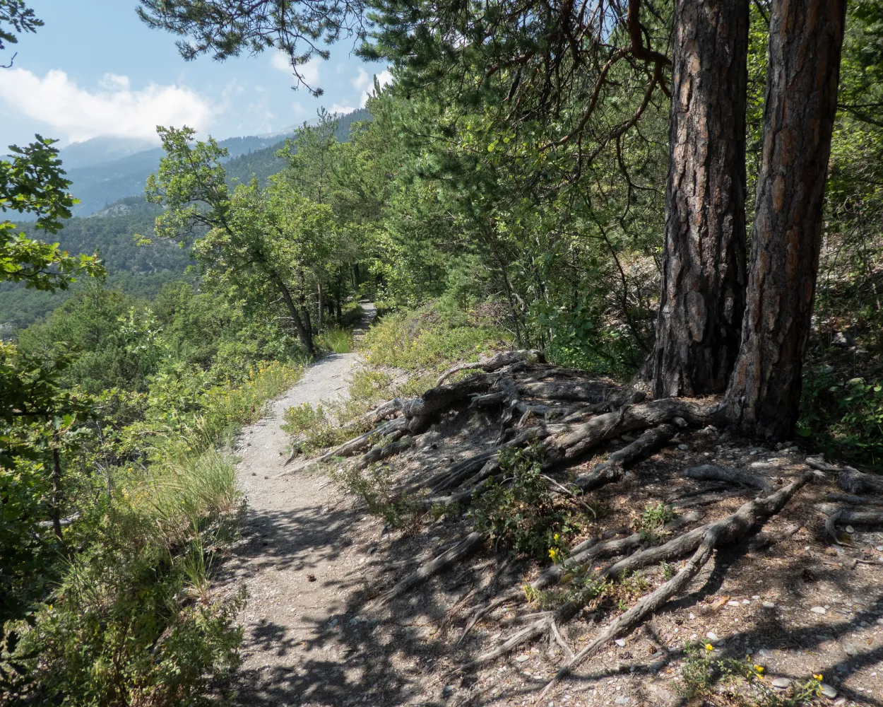
This hike starts in the Valais village of Inden, which can be reached by bus or on foot from Leuk or Leukerbad. As far back as the late Middle Ages, the Romans used this route to reach the thermal springs in Leukerbad, the most productive in the Alps. The hike starts at the former train station and follows the Dala-Raspille cultural trail and the route of the former Leuk-Leukerbad railroad (1915-1967). The trail continues up past a mountain flank, which Johann Wolfgang von Goethe described in 1779 as "not a dangerous trail, but one that looks very frightening". Despite being exposed in places, the path is wide, technically easy and partly secured with wire ropes. You will be rewarded with a sweeping view of the wild Dala valley and the opposite side. Cross the German-French language border, the Raspille river, and follow the trail down to the village of Miège, where the bus will take you back to Sierre.
10.69 km244 m680 m3h 15mDifficulty: Medium
Maximum elevation: 1140m
Minimum elevation: 699m
Learn more on
valais.ch
| Leukerbad, City (09:21) | |
| 481 (5m) | |
| Leukerbad, Obere Maressen (09:26) |
| Leukerbad, Obere Maressen (09:56) | |
| 481 (6m) | |
| Leukerbad, Busterminal (10:02) |
| Leukerbad, Busterminal (10:43) | |
| 471 (9m) | |
| Inden, Dorf (10:52) |
Pleasant hike from Montana along the Bisse du Tsittoret, past inviting mountain inns into the valley of the Tièche. Then on a sunny slope over Varneralp to Leukerbad, where weary hikers can relax in the warm thermal spa.
24 km1150 m1250 m7h 40m
Landscape: With panoramic views,Onto an alp
Tour published by:
SwitzerlandMobility
Learn more on
schweizmobil.ch
Scenic high-level trail with panoramic views of the Valais Alps and views down into the Rhone Valley. Variety of attractions along the route: thermal spa in Leukerbad, viaducts on the Lötschberg-Südrampe, splashing water channels and the Museum of the Swiss Guard at Naters.
76 km3300 m4100 mLandscape: With panoramic views
Tour published by:
SwitzerlandMobility
Learn more on
schweizmobil.ch
| Leukerbad, City (09:21) | |
| 481 (5m) | |
| Leukerbad, Obere Maressen (09:26) |
| Leukerbad, Obere Maressen (09:56) | |
| 481 (1m) | |
| Leukerbad, Lärchenwald (09:57) |

An age-old trail leads to the quaint village of Albinen in a superb location above the Dalaschlucht (gorge); along the way, the ancient hamlets of Brentschen, Engersch and Jeizinen also sit on the sunny slope, linked by peaceful hiking paths.
23 km1000 m1750 m7h 30mLandscape: With panoramic views,Onto an alp
Tour published by:
SwitzerlandMobility
Learn more on
schweizmobil.ch
This spectacular route shows the great diversity of the Valais within a compact area. Culture, history, impressive mountains, canyons, old irrigation channels, a charming winegrowing region and natural landscape – explore all this by crossing the Raspille river and the German-French language border.
11 km300 m740 m3h 10mLandscape: With panoramic views
Tour published by:
SwitzerlandMobility
Learn more on
schweizmobil.ch
Difficulty: Medium
Maximum elevation: 1401m
Minimum elevation: 577m
Difficulty: Medium
Maximum elevation: 1554m
Minimum elevation: 1270m
Difficulty: Medium
Maximum elevation: 2997m
Minimum elevation: 2312m
Learn more on
valais.ch
Learn more on
valais.ch
Learn more on
valais.ch


