Discover a world of alpine beauty and scenic trails, all easily accessible from Fiesch by public transport. From the picturesque Binntal valley to the panoramic Gommer Höhenweg, these routes offer a mix of challenging ascents, serene mountain lakes, and charming historical villages. Wander through lush meadows, fragrant larch forests, and past ancient Roman bridges, all while taking in breathtaking views of the Valais 4000-meter peaks.
The following hikes are sorted by travel time from Fiesch, making it easy to plan your adventure based on your schedule and energy level. Check out the map to explore thousands of destinations and activities, reachable from any starting point in Switzerland.
Much more on ovunta.com/en/map
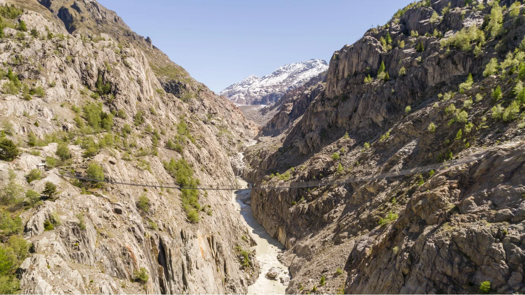
Part of the route between Fiesch and Lax is inaccessible following a landslide this spring near the Altbach stream. Following the success of the Stoneman Glaciara for mountain bikers, here is the Stoneman Glaciara Hike, an exclusive adventure for hikers and trail runners. Experience these magical routes on paths deep within mystical forests leading up to incredible views of a sea of mountain peaks of over 4,000 m high. On the program: a breathtaking 3,150 metre difference in height, two suspension bridges spanning the valley, a spectacular ridge walk and the billions of tons of ice of Central Europe’s mightiest glacier – that’s the Stoneman Glaciara Hike. It is entirely up to you whether you wish to trail run or hike, and experience the Stoneman Glaciara Hike in one, two or three daily stages. Get the official starter pack and follow the perfectly signposted route for a stunning adventure.
 63.37 km
 3341 m
 3341 m
 22h 35m
Difficulty: Hard

Maximum elevation: 2839m

Minimum elevation: 1005m
Learn more on
valais.ch
| Fiesch (08:55) | |
| R43 (2m) | |
| Fiesch Feriendorf (08:57) |
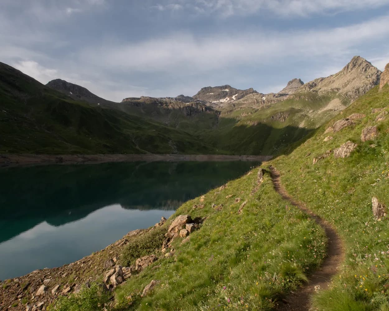
This hike starts in the small village of Ernen. The path initially passes through the forest, gradually leading you to Niederärner Chäller on a beautiful shaded track, before crossing through the wild valley of Rappental along the Milibach stream. The route then runs along the edge of the forest up until Lärch, which marks the highest point of the hike. Continue your outing along a small path bordered by magnificent alpine flowers until you reach the breathtaking vantage point of Chäserstatt and its cozy mountain hotel. After a relatively steep descent, you will reach the pretty village of Mühlebach and the famous Goms suspension bridge, before arriving at Fürgangen train station.
13.31 km1030 m1020 m5h 10mDifficulty: Hard
Maximum elevation: 2120m
Minimum elevation: 1202m
Learn more on
valais.ch
| Fiesch (08:56) | |
| R43 (6m) | |
| Fürgangen-Bellwald Talstation (09:02) |
The Trusera is the most easterly Suone – or irrigation channel – of any significance in the Valais. First mentioned in a purchase document dating from 1499, it draws its water from the Milibach stream in the Rappental valley. The irrigation channel was out of use between 1994 and 2006, but was later restored by numerous helpers at great financial expense. For the most part, it runs through shady forests, serving to irrigate herb gar- dens in the Binnackern area. During the blooming period, various types of native orchid, including the red hellborine, adorn the footpath.
8.2 km395 m3h 0mDifficulty:

Landscape: Along the water,Along a Suone/Bisse
Learn more on
valais.ch
and on
valrando.ch
| Fiesch, Bahnhof (08:58) | |
| 652 (4m) | |
| Ernen, Z'Brigg (09:02) |
This exhilarating ascent of the Eggerhorn (2,503 m) starts in the main Rhône valley and concludes with a descent beyond into the wild Binntal valley. The contrasts along the way and the spectacular summit views of the two valley systems make for an unforgettable hike. In fact the entire route lies within the confines of the Binntal Landscape Park, known for its pristine scenery, geological variety and wealth of plant and animal life. The historical villages seem to live in a state of suspended animation, having been bypassed by modern traffic routes; several have won awards for their superb state of preservation.
14.8 km1419 m1101 m6h 45mDifficulty: Hard
Maximum elevation: 2502m
Minimum elevation: 1199m
Learn more on
valais.ch
| Fiesch, Bahnhof (08:58) | |
| 652 (9m) | |
| Ernen, Dorfplatz (09:07) |
An ancient trade route connected the upper Rhône valley with Lombardy via the village of Grengiols, the Binntal valley and the Albrun Pass. Today, the lower section of the “Römerweg” (“Roman Path”) offers walkers a delightful experience of the pristine scenery of the Binntal Landscape Park, picturesque hamlets and charming Grengiols. This historical village has remained virtually unchanged since 1861, when the new Furka Pass road diverted traffic to the northern side of the Rhône valley. The trail begins at a remote bus stop on the road into the Binntal valley, just before the main tunnel, and finishes at Betten railway station, on the floor of the Rhône valley. Along the way, it leads through fragrant pine forest and across flower-filled meadows, with glorious views of the dramatic Binntal gorges and the sweeping Rhône valley. From Steinmatten bus stop, the trail drops down to the Römerbrücke (“Roman bridge”) across the Binn river before climbing through peaceful forest to a pair of sleepy hamlets – Blatt and Hockmatta – each with an ancient chapel. Further on, Grengiols is known as the home of a wild variety of tulip, unique worldwide. The protected plants are known in local dialect as “Roman tulips”; about 3,000 blossom each spring, usually in the second half of May, in the village’s old rye fields. An attractive theme trail leading to the “tulip hill” and other natural sites opened in 2009, with the addition of a brand-new path across open meadows and through forest in 2014. Our hike follows first the new extension and then part of the original trail before reaching the village heart. With its narrow, steep main alley and picturesque village square, Grengiols is a historical site of national importance. Highlights: Ancient trail through forest, meadows and sleepy hamlets, with gorgeous views Theme trail devoted to the Grengiols tulip, unique worldwide
12.97 km86 m656 m3h 45m| Fiesch (08:55) | |
| R43 (14m) | |
| Grengiols (09:09) |
Situated at the foot of the Fiesch Glacier, 120 metres above the waters of the Weisswasser River, the Aspi-Titter bridge connects the Conches Valley to the Aletsch Glacier. The bridge allows the public to access the enchanting landscapes of the Aletsch Arena’s resorts after a demanding hike. The Aletsch Glacier, a UNESCO World Heritage Site, is visible along the entire route. Experienced hikers can also look forward to landscapes shaped by the eternal ice, colourful alpine flora and an idyllic glacial lake.
15.57 km358 m1449 m5h 30mDifficulty: Medium
Maximum elevation: 2652m
Minimum elevation: 1559m
Learn more on
valais.ch
| Fiesch (08:56) | |
| R43 (6m) | |
| Fürgangen-Bellwald Talstation (09:02) |
| Fürgangen (Talstation) (09:05) | |
| 2345 (6m) | |
| Bellwald (Bergstation) (09:11) |
The starting point of the hike is the Bettmerhorn view point, two minutes’ walk from the Bettmerhorn cable-car mountain station (2,647m). At first the route takes you gently downwards via “Uf de Setzu” towards Roti Chumma. The Great Aletsch Glacier is constantly in your sights on this section of the trail, and each step brings you closer. Following the path cut in the rock with stone steps, you head towards Märjela, Märjelensee and the “Gletscherstube” mountain hut. You return to the sunny plateau of the Aletsch Arena via Unneres Tälli or Oberes Tälli (or take a shortcut through the kilometre-long, illuminated Tälligrattunnel). Walk as far as Salzgäb and then follow the path downhill to Fiescheralp. The last section of this fantastic hike takes you back to Bettmeralp.
15.13 km185 m900 m5h 30mDifficulty: Medium
Maximum elevation: 2647m
Minimum elevation: 1924m
Learn more on
valais.ch
| Fiesch (Talstation) (08:33) | |
| R1 (10m) | |
| Fiescheralp (08:43) |
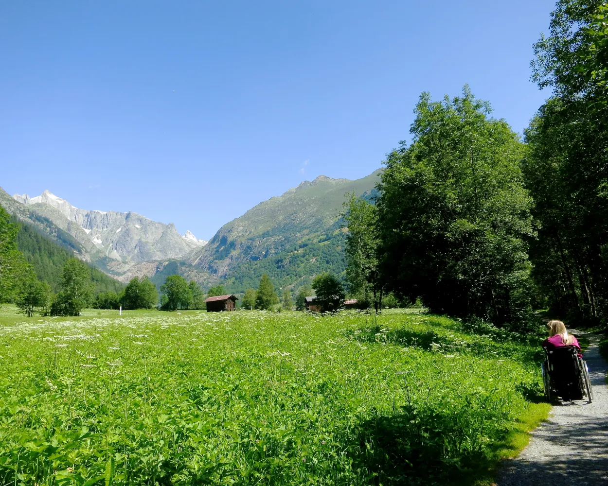
An excursion from Fiesch to the Fieschertal - always alongside the lively Wysswasser river - is the purest of natural experiences. Here the mountain landscape of the Valais is presented at it's best. It's impossible to do anything but relax and enjoy it.
3 km70 m20 m40m
Barrier free: Yes
Landscape: Along the water
Tour published by:
SwitzerlandMobility
Learn more on
schweizmobil.ch
| Fiesch, Bahnhof (08:58) | |
| 651 (5m) | |
| Fieschertal, Dorfplatz (09:03) |
Three days under the spell of the Valais glacier landscape. Sensational scenic tour with many vantage points onto the two longest glaciers in the Alps. The grey-white of ice and rock contrasting with shades of green in the Aletschwald (forest) provides stunning scenic beauty.
30 km1850 m2400 m9h 0mLandscape: With panoramic views,Along a glacier,Over a suspension bridge
Tour published by:
SwitzerlandMobility
Learn more on
schweizmobil.ch
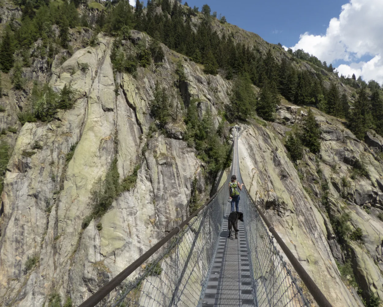
The trail follows old Alpine paths down to the Burg, a rock massif of gneiss smoothed by glaciers. Against the backdrop of the Goms mountains, the Fiescher Glacier becomes clearly visible. The 160-metre-long Aspi-Titter suspension bridge points the way to the idyllic Goms mountain village of Bellwald.
9 km340 m1150 m3h 20mLandscape: With panoramic views,Over a suspension bridge
Tour published by:
SwitzerlandMobility
Learn more on
schweizmobil.ch
Difficulty:
Maximum elevation: 1405m
Minimum elevation: 830m
Learn more on
valais.ch


