Discover a world of alpine beauty with these ten hiking destinations, all accessible by public transport from Evolène. From the lush meadows of Val d'Hérens to the sparkling Lac Bleu and the towering peaks of the Aiguilles Rouges, each trail offers a unique glimpse into the natural splendor of the Swiss Alps. Whether you're looking for gentle walks or challenging mountain routes, you'll find paths that lead to unforgettable vistas and charming mountain huts.
The hikes are listed in order of travel time from Evolène, making it easy to plan your adventure. Check out the map to explore thousands of destinations and activities, reachable from any starting point in Switzerland.
Much more on ovunta.com/en/map
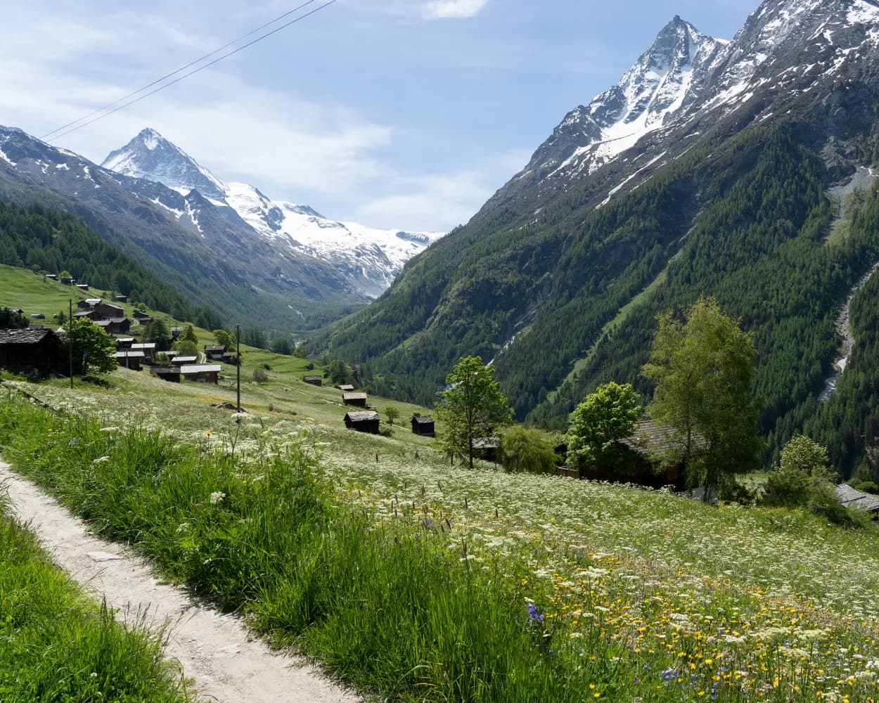
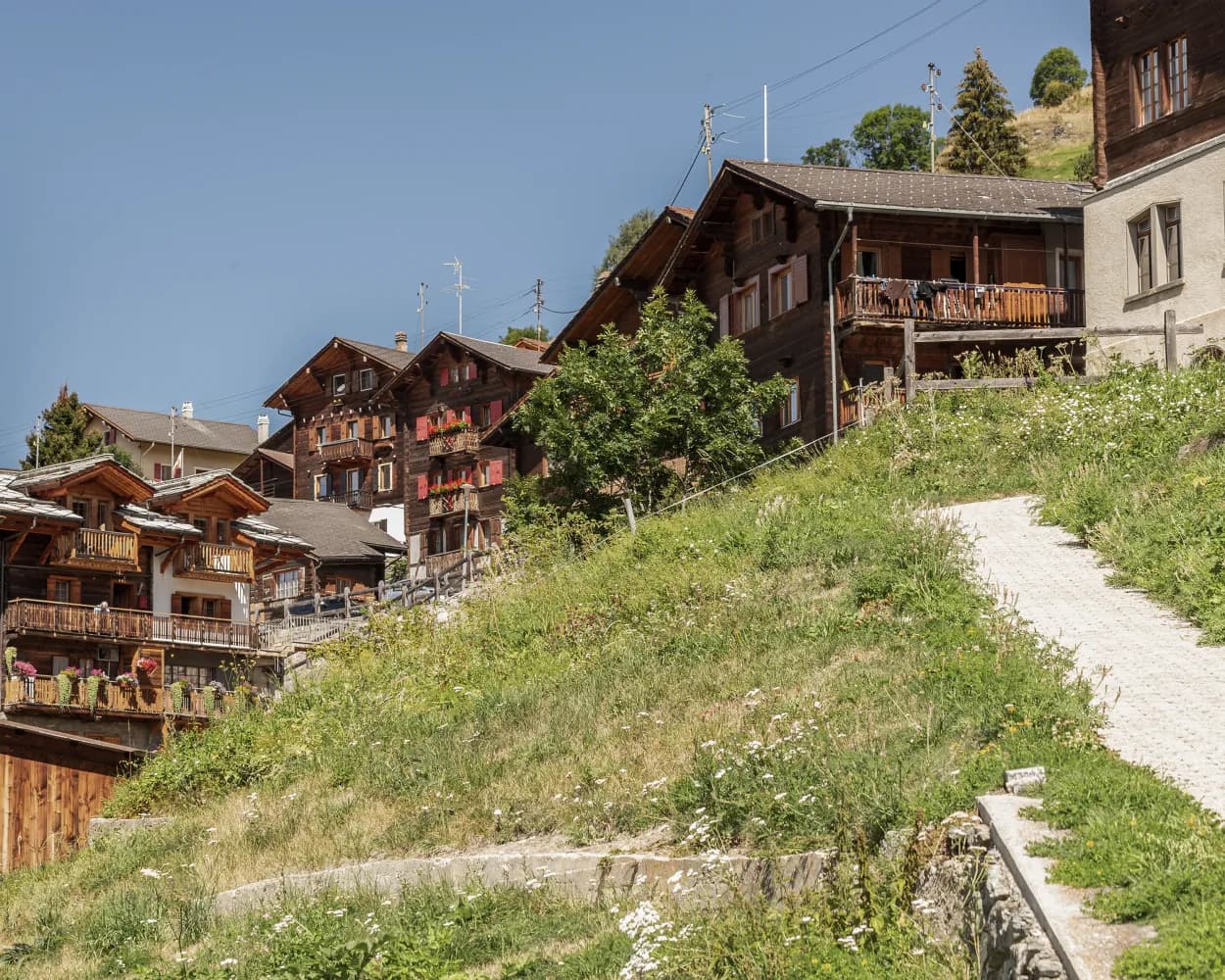
A cluster of well-preserved historical villages forms the cultural and social heart of the upper Val d’Hérens. Evolène and Les Haudères, the two largest, lie among the low meadows on the valley floor. Three other villages – La Forclaz, La Sage and Villaz – stand on a glacial terrace that makes a sunny balcony about 300 metres higher up, surrounded by pastures. The villages have lovingly restored their characteristic wooden houses and barns, beautifully decorated with flowers. Evolène was voted the prettiest village in French-speaking Switzerland in 2012, and is an official Swiss heritage site – like Les Haudères. Framed by alpine meadows and fragrant forests, they have retained all their historical charm. The pastures that surround the villages are the ancestral home of the stocky black cows of the Herens breed, which take their name from the valley – and have become a symbol of Valais. These combative cows fight naturally in order to establish a hierarchy in the herd; hikers will often see pairs lock horns until one turns tail. Organised fights are a popular attraction for locals and tourists alike; the cows’ Raclette cheese, served melted, is prized throughout Switzerland. Highlights: Historical villages of wooden houses and barns, beautifully preserved Walk on two levels – valley floor and sunny glacial terrace 300 m higher Cultural heart of upper valley: markets with farmers and artisans in traditional costume
 11.09 km
 500 m
500 m 500 m
500 m 3h 25m
Difficulty:

Maximum elevation: 1730m

Minimum elevation: 1342m
Learn more on
valais.ch
The third leg of the 5-stage Tour du Val d’Hérens offers a complete contrast to the two previous high-altitude stages, focusing on the lower slopes and charming historical villages. The stage starts at its highest point: Arolla, the village takes its name from the tree that dominates the forests along the valley floor: the Arolla pine (pinus cembra). These trees are a constant companion along the first part of the trail, which leads the length of the Val d’Arolla, criss-crossing the river – at one point via a 75-metre suspension footbridge opened in 2017. The second half of the walk is a tour of the villages that form the cultural heart of the Val d’Hérens. From Les Haudères by the river, the trail climbs up to La Forclaz and La Sage, perched on the sunny slopes a couple of hundred metres above the valley floor, before twisting back down to Evolène. These villages of ancient houses and wooden barns, framed by flower-filled meadows, have preserved all their authentic charm. At summer markets, visitors still see merchants, artisans and farmers in traditional local costume. The valley is also known for its fascinating geology, which visitors can explore with the help of a free app, «GéoGuide Val d’Hérens» (details at www.evolene-geologie.ch). Les Haudères has its own «Centre de géologie et de glaciologie», with a permanent exhibition; the tourist office at Evolène can provide further printed information. This stage of the Tour du Val d’Hérens also offers a number of variants: alternative routes via idyllic mountain lakes, plus the option to finish and stay the night at one of the other villages. Highlights Descent of the Val d’Arolla – idyllic high-altitude valley Sequence of historical villages, beautifully preserved and full of period charm Fascinating geology, with local museum, app, online guide and theme trails
17.1 km342 m981 m5h 10mDifficulty: Medium
Maximum elevation: 2012m
Minimum elevation: 1371m
| Evolène, Village (09:22) | |
| 381 (1m) | |
| Evolène, Route de Lannaz (09:23) |
This loop offers a chance to discover the authentic villages of the Evolène region. Three distinct sections feature a variety of landscapes and levels of difficulty. The first stretch consists of a fairly steep climb of about 400 vertical metres. This is followed by a shallower but exhilarating descent across the mountainsides, with a final leg along the river of La Borgne.
10.51 km426 m427 m2h 2mDifficulty:
Maximum elevation: 1729m
Minimum elevation: 1342m
Learn more on
valais.ch
| Evolène, Village (09:22) | |
| 381 (2m) | |
| Evolène, La Fauchère (09:24) |
The jewel of the municipality of Saint-Martin is the Ossona plateau, which was abandoned several decades ago but has been given a new lease of life thanks to a complete restoration. The path from Les Prixes to La Luette takes you through the agritourism hamlet of Ossona and then across the suspension footbridge of the same name. The hamlet is situated at the heart of an extensive network of footpaths, and now offers a wide range of outdoor activities including archery, observing wild flora and fauna, meeting farm animals, walks along theme trails and rock climbing. To make the most of this enchanting landscape, you can stay in one of the restored houses, which feature all modern comforts.
7.72 km335 m505 m2h 30mDifficulty: Medium
Maximum elevation: 1168m
Minimum elevation: 923m
Learn more on
valais.ch
| Evolène, Village (09:48) | |
| 381 (10m) | |
| La Luette (09:58) |
Travel between rocky passes and intensely green valleys from Verbier to Zermatt, through larch forests and juniper bushes, across vast expanses and along icy blue glaciers. Be sure to observe the changes in landscape, language, cuisine and culture as you move through the valleys. This high altitude route for trail runners does not follow the most direct line from start to finish, but skirts the buttresses, choosing the most picturesque and practicable paths through the Valais in the heart of the Swiss Alps. Each leg finishes in a charming mountain village or in a hut if the route continues at high altitude.
308.24 km18498 m18537 m69h 15mDifficulty: Hard
Maximum elevation: 3346m
Minimum elevation: 688m
Learn more on
valais.ch
| Evolène, Village (09:48) | |
| 381 (17m) | |
| Euseigne, Les Grangettes (10:05) |
Initially along the Borgnes river, then up into the villages high on the cliffs. Typical homes, barns and chapels are found around Evolène in a protected landscape with views across the mountains and the untamed Val d’Hérens. And finally, a section of the trail with paintings and poetry.
11 km520 m520 m3h 25m
Landscape: With panoramic views
Tour published by:
SwitzerlandMobility
Learn more on
schweizmobil.ch
Hike between Les Prixes and La Luette with a spectacular passage across the 133 m Grande Combe suspension bridge. Just before the bridge is the hamlet of Ossona on a plateau in the heart of the Val d’Hérens, a showcase project for gentle and sustainable agritourism.
8 km360 m540 m2h 35mLandscape: With panoramic views,Over a suspension bridge
Tour published by:
SwitzerlandMobility
Learn more on
schweizmobil.ch
The skilfully laid «bisses» irrigation channels are evidence of Valais history and culture. Fabulous flora along the way, the babbling water so soothing. The «Chemin des Bisses», a hike for all senses, follows the holy waters.
105 km4700 m4600 mLandscape: Along the water,Onto an alp,With panoramic views
Tour published by:
SwitzerlandMobility
Learn more on
schweizmobil.ch
This stage continues along the Bisse de Vex from Veysonnaz to St. Martin. The route not only offers a variety of scenic impressions, but also cultural highlights that emphasise the charm of the region. The impressive concrete church in Hérémence and the fascinating earth pyramids in Euseigne are unforgettable high points of this stage.
18 km950 m880 m5h 45mLandscape: With panoramic views,Along the water
Tour published by:
SwitzerlandMobility
Learn more on
schweizmobil.ch
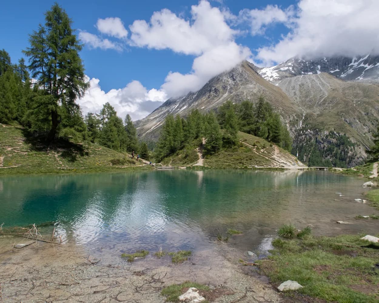
At the foot of gleaming glacier giants and rocky peaks in the Val d'Arolla, through forests and across lush meadows with rich flora. Along the way you will be enchanted by the sparkling blue Lac Bleu, from where it is not far to the mountaineering village of Arolla.
15 km1500 m880 m6h 15mTour published by:
SwitzerlandMobility
Learn more on
schweizmobil.ch
| Evolène, Village (09:22) | |
| 381 (10m) | |
| Les Haudères, centre (09:32) |
| Les Haudères, centre (09:37) | |
| 381 (11m) | |
| Les Haudères, Les Juttes (09:48) |
Learn more on
valais.ch