Scopri un mondo di bellezza alpina con queste dieci destinazioni escursionistiche, tutte raggiungibili con i mezzi pubblici da Evolène. Dai prati rigogliosi della Val d'Hérens al scintillante Lac Bleu e alle imponenti vette delle Aiguilles Rouges, ogni sentiero offre uno scorcio unico sullo splendore naturale delle Alpi svizzere. Che tu stia cercando passeggiate tranquille o percorsi montani impegnativi, troverai sentieri che conducono a panorami indimenticabili e a rifugi di montagna affascinanti.
Le escursioni sono elencate in ordine di tempo di viaggio da Evolène, rendendo facile pianificare la tua avventura. Esplora la mappa per scoprire migliaia di destinazioni e attività, raggiungibili da qualsiasi punto di partenza in Svizzera.
Molto di più su ovunta.com/it/map
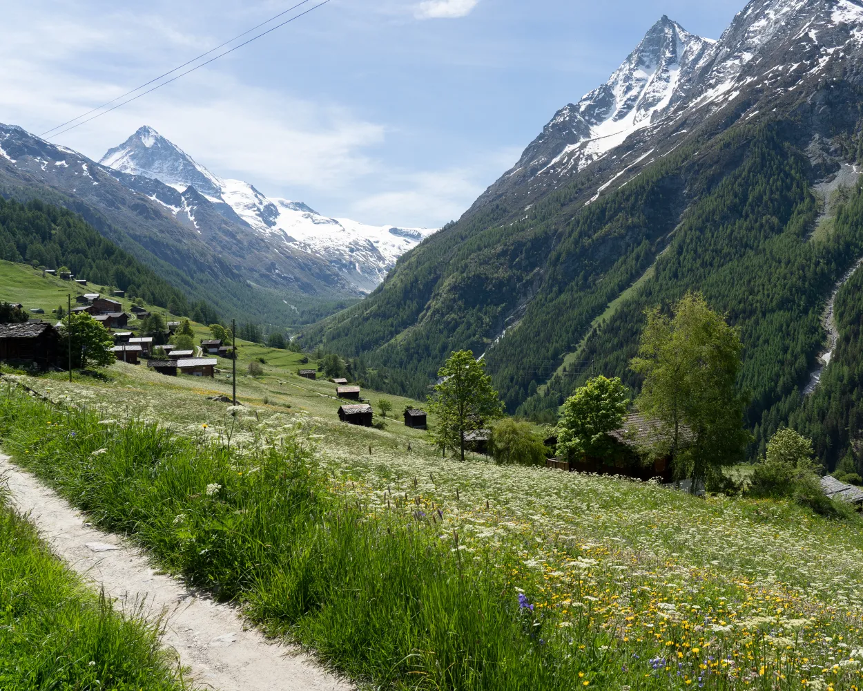
The third leg of the 5-stage Tour du Val d’Hérens offers a complete contrast to the two previous high-altitude stages, focusing on the lower slopes and charming historical villages. The stage starts at its highest point: Arolla, the village takes its name from the tree that dominates the forests along the valley floor: the Arolla pine (pinus cembra). These trees are a constant companion along the first part of the trail, which leads the length of the Val d’Arolla, criss-crossing the river – at one point via a 75-metre suspension footbridge opened in 2017. The second half of the walk is a tour of the villages that form the cultural heart of the Val d’Hérens. From Les Haudères by the river, the trail climbs up to La Forclaz and La Sage, perched on the sunny slopes a couple of hundred metres above the valley floor, before twisting back down to Evolène. These villages of ancient houses and wooden barns, framed by flower-filled meadows, have preserved all their authentic charm. At summer markets, visitors still see merchants, artisans and farmers in traditional local costume. The valley is also known for its fascinating geology, which visitors can explore with the help of a free app, «GéoGuide Val d’Hérens» (details at www.evolene-geologie.ch). Les Haudères has its own «Centre de géologie et de glaciologie», with a permanent exhibition; the tourist office at Evolène can provide further printed information. This stage of the Tour du Val d’Hérens also offers a number of variants: alternative routes via idyllic mountain lakes, plus the option to finish and stay the night at one of the other villages. Highlights Descent of the Val d’Arolla – idyllic high-altitude valley Sequence of historical villages, beautifully preserved and full of period charm Fascinating geology, with local museum, app, online guide and theme trails
 17.1 km
 342 m
342 m 981 m
981 m 5h 10m
| Evolène, Village (09:22) | |
| 381 (1m) | |
| Evolène, Route de Lannaz (09:23) |
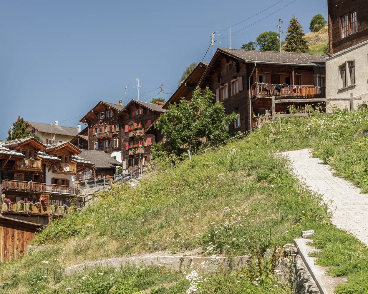
A cluster of well-preserved historical villages forms the cultural and social heart of the upper Val d’Hérens. Evolène and Les Haudères, the two largest, lie among the low meadows on the valley floor. Three other villages – La Forclaz, La Sage and Villaz – stand on a glacial terrace that makes a sunny balcony about 300 metres higher up, surrounded by pastures. The villages have lovingly restored their characteristic wooden houses and barns, beautifully decorated with flowers. Evolène was voted the prettiest village in French-speaking Switzerland in 2012, and is an official Swiss heritage site – like Les Haudères. Framed by alpine meadows and fragrant forests, they have retained all their historical charm. The pastures that surround the villages are the ancestral home of the stocky black cows of the Herens breed, which take their name from the valley – and have become a symbol of Valais. These combative cows fight naturally in order to establish a hierarchy in the herd; hikers will often see pairs lock horns until one turns tail. Organised fights are a popular attraction for locals and tourists alike; the cows’ Raclette cheese, served melted, is prized throughout Switzerland. Highlights: Historical villages of wooden houses and barns, beautifully preserved Walk on two levels – valley floor and sunny glacial terrace 300 m higher Cultural heart of upper valley: markets with farmers and artisans in traditional costume
11.09 km500 m500 m3h 25m
Altitudine massima: 1730m

Altitudine minima: 1342m

Difficoltá:
Learn more on
valais.ch
This loop offers a chance to discover the authentic villages of the Evolène region. Three distinct sections feature a variety of landscapes and levels of difficulty. The first stretch consists of a fairly steep climb of about 400 vertical metres. This is followed by a shallower but exhilarating descent across the mountainsides, with a final leg along the river of La Borgne.
10.51 km426 m427 m2h 2mAltitudine massima: 1729m
Altitudine minima: 1342m
Difficoltá:
Learn more on
valais.ch
| Evolène, Village (09:22) | |
| 381 (2m) | |
| Evolène, La Fauchère (09:24) |
The jewel of the municipality of Saint-Martin is the Ossona plateau, which was abandoned several decades ago but has been given a new lease of life thanks to a complete restoration. The path from Les Prixes to La Luette takes you through the agritourism hamlet of Ossona and then across the suspension footbridge of the same name. The hamlet is situated at the heart of an extensive network of footpaths, and now offers a wide range of outdoor activities including archery, observing wild flora and fauna, meeting farm animals, walks along theme trails and rock climbing. To make the most of this enchanting landscape, you can stay in one of the restored houses, which feature all modern comforts.
7.72 km335 m505 m2h 30mAltitudine massima: 1168m
Altitudine minima: 923m
Difficoltá: Media
Learn more on
valais.ch
| Evolène, Village (09:48) | |
| 381 (10m) | |
| La Luette (09:58) |
Travel between rocky passes and intensely green valleys from Verbier to Zermatt, through larch forests and juniper bushes, across vast expanses and along icy blue glaciers. Be sure to observe the changes in landscape, language, cuisine and culture as you move through the valleys. This high altitude route for trail runners does not follow the most direct line from start to finish, but skirts the buttresses, choosing the most picturesque and practicable paths through the Valais in the heart of the Swiss Alps. Each leg finishes in a charming mountain village or in a hut if the route continues at high altitude.
308.24 km18498 m18537 m69h 15mAltitudine massima: 3346m
Altitudine minima: 688m
Difficoltá: Difficile
Learn more on
valais.ch
| Evolène, Village (09:48) | |
| 381 (17m) | |
| Euseigne, Les Grangettes (10:05) |
Si segue il corso del fiume Borgne e poi si sale ai cosiddetti villaggi sulle rocce. Nei pressi di Evolène, in un paesaggio protetto, si scoprono le tipiche case, i fienili e le cappelle, con vista sulle montagne e sulla selvaggia Val d'Hérens. Nell’ultimo tratto c’è un sentiero dedicato alla pittura e alla poesia.
11 km520 m520 m3h 25m
Paesaggio: Con vista panoramica
Tour pubblicato da:
SvizzeraMobile
Learn more on
schweizmobil.ch
Escursione tra Les Prixes e La Luette con lo spettacolare ponte sospeso «Grande Combe» di 133 metri, preceduto da una visita a Ossona, sull'altopiano nel cuore della Val d'Hérens: un progetto esemplare per un agriturismo delicato e sostenibile.
8 km360 m540 m2h 35mPaesaggio: Su un ponte sospeso,Con vista panoramica
Tour pubblicato da:
SvizzeraMobile
Learn more on
schweizmobil.ch
Costeggiando il Bisse de Vex, questa tappa si sviluppa da Veysonnaz a St-Martin. Oltre a una varietà di impressioni paesaggistiche il percorso offre attrazioni culturali di rilievo che mettono in evidenza il fascino della regione. L’imponente chiesa in cemento di Hérémence e le affascinanti piramidi di terra di Euseigne rappresentano momenti indimenticabili di questa esperienza.
18 km950 m880 m5h 45mPaesaggio: Lungo l'acqua,Con vista panoramica
Tour pubblicato da:
SvizzeraMobile
Learn more on
schweizmobil.ch

Testimonianze della storia e della cultura del Vallese sono le «bisse», le artistiche condutture idriche. Una flora rigogliosa costeggia il percorso, il mormorio dell’acqua ha un effetto rilassante. Lo «Chemin des Bisses» segue il corso delle sacre acque.
105 km4700 m4600 mPaesaggio: Con vista panoramica,Su un alpeggio,Lungo l'acqua
Tour pubblicato da:
SvizzeraMobile
Learn more on
schweizmobil.ch
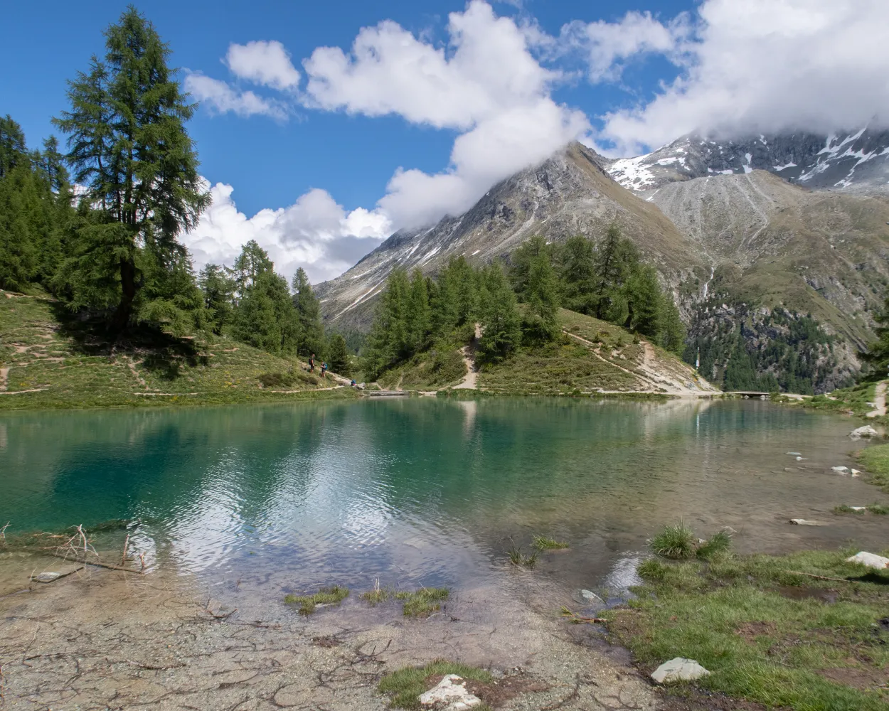
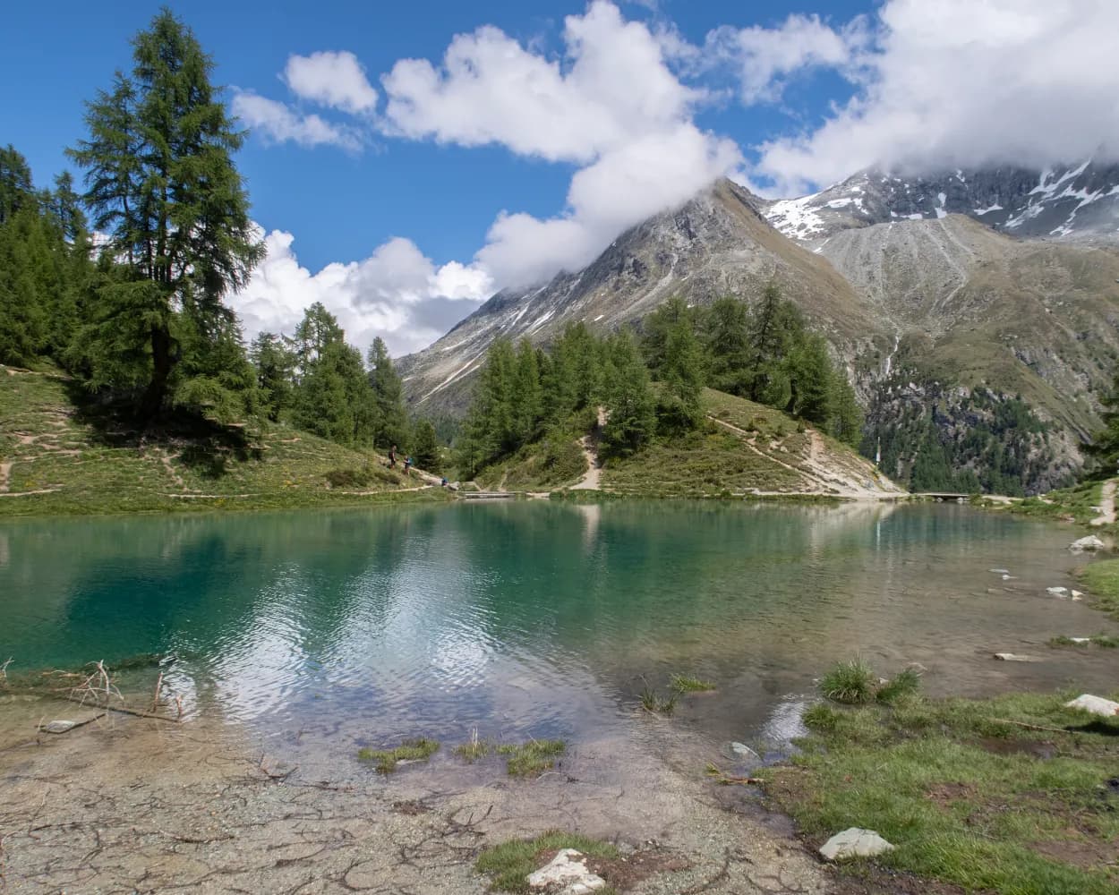
Ai piedi degli scintillanti ghiacciai e delle cime rocciose della Val d'Arolla attraverso boschi, prati e pascoli con una ricca flora. Strada facendo si giunge allo splendente Lac Bleu, non molto lontano dal villaggio alpinistico di Arolla.
15 km1500 m880 m6h 15mTour pubblicato da:
SvizzeraMobile
Learn more on
schweizmobil.ch
| Evolène, Village (09:22) | |
| 381 (26m) | |
| Les Haudères, Les Juttes (09:48) |
Altitudine massima: 2012m
Altitudine minima: 1371m
Difficoltá: Media
Learn more on
valais.ch


